Your guide to climate-informed marine spatial planning


AlexandriaNorris Moore
Whether it’s through fishing, wind power, the transportation of goods, or tourist activities, the ocean provides a vital combination of economic and social benefits to coastal communities in the APAC region.
In fact, globally it’s the world’s 7th largest economy, with assets worth around US$24 trillion and an annual value of goods and services of US$2.5 trillion.
With various stakeholders relying on the ocean for different interests, ensuring everyone is catered for and activities are conducted in a responsible and sustainable way can be a major challenge. And it’s one that’s gaining more and more attention.
The UN’s sustainability goals now dictate that countries must have a plan for how they promote marine resources, and the public consciousness is increasingly aware that efforts to protect natural environments are approaching a “now or never” stage. So, what’s the solution?
Marine spatial planning and climate-informed Marine Spatial Planning plays a pivotal role in solving these challenges in the years to come.
What is climate-informed Marine Spatial Planning (MSP)?
Marine Spatial Planning (MSP) is a public process that analyses and allocates the spatial and temporal distribution of human activities in marine areas to create a framework that ensures people, the economy, and the environment can all benefit.
Climate-informed marine spatial planning (MSP) incorporates climate related knowledge and considerations into the MSP process. It takes into account the impacts of climate change on marine ecosystems, such as rising sea levels, changing ocean temperatures, and extreme weather events, and integrates strategies to adapt to and mitigate these impacts.
Climate-informed MSP integrates climate change considerations and adaptation strategies into traditional MSP practices to ensure that marine spatial plans are resilient to the effects of climate change.
Today, the challenge of marine spatial planning is more difficult than ever with climate change and environmental concerns dictating the problems we face. Unpredictable weather and rising sea levels make it difficult to accurately predict what the future might hold, and they’re also having devastating impacts on coastal locations.
But, unless we begin to think more carefully about the way we use our oceans, these resources may soon no longer exist to protect.
The challenges of marine spatial planning in APAC
Stakeholder coordination
The primary challenge with marine spatial planning is the number of different parties involved, and their corresponding – sometimes conflicting – objectives. Like most multi-stakeholder activities, understanding these needs and finding common ground can be an intricate, complex, and time-consuming activity.
It is vital, though, that all stakeholders are accounted for – whether that’s at a ministry or local community level. Failure to do so can result in all manner of opposition, so understanding the intricacies of each party’s requirements is a vital first step to building a robust plan.
Data and capacity limitation
The other major challenge is planning for the future. Marine spatial planning has to think far beyond what’s happening today and account for future developments, too. And it requires a huge amount of data and technologies like predictive analytics to create solutions that will stand the test of time.
Insufficient funding and regulatory frameworks
When working with governments and private entities in the APAC region, we often encounter existing plans implemented by local municipalities to tackle issues like coastal erosion. And they regularly include high-level, short-term fixes.
The pace of environmental change in today’s world is not suited to this way of thinking. In fact, it’s vital that flexibility is built into the core of any solution, so the actions outlined can adapt as markets, technology, and the environment changes. In doing so, we can protect environments, economies, and some of the most vulnerable members of society today and tomorrow.
We recommend considering multiple different scenarios from the outset, and updating plans every five years to adapt to changing conditions.
As you can imagine, all of this takes time – from based-line assessing and identifying issues to meeting with stakeholders and getting plans signed off. Realistically, successful marine spatial planning can take years. Which is why now is the best time to start.
Currently, several countries in APAC are already in the process of developing masterplans which should be in place within the next few years, and will provide a roadmap for the foreseeable future.
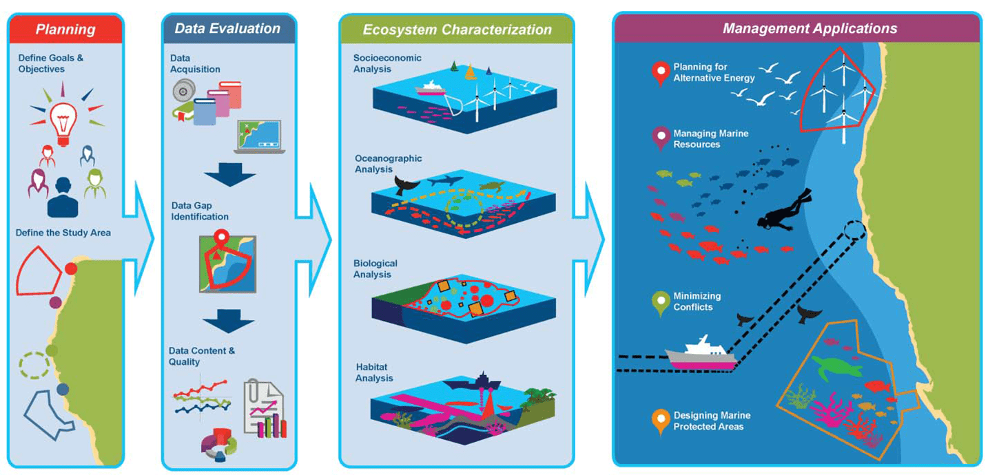
Source: https://coastalscience.noaa.gov/news/innovative-management-approach-aids-marine-spatial-planning/
An expert-led, future-facing approach
Haskoning is an industry leader in innovative and sustainable coastal and marine planning and development, and we have extensive experience in marine environments, port planning, and land-use planning.
Our multi-sector and multi-disciplinary expertise means we’re able to provide leading commercial, technical, and operational advice – and create strategies for a wide range of projects.
All of our guidance is tailored to the needs of specific locations. Our permanent presence in the APAC region means we can incorporate local knowledge into the work we do. We understand communities, stakeholders, and natural environments in a truly granular way that allows us to find the best solutions.
Our process sees us identify, engage, and unite stakeholders; gather and analyse data from various sources to identify key challenges; and apply technical information to conceive solutions for a wide range of possible scenarios.
This process has been used on coastal rehabilitation and flood risk assessment projects all over the world. We incorporate climate change data and deploy nature-based solutions – like artificial sandbanks, mangroves, or coral reefs – wherever possible, to find the most sustainable solutions to pressing challenges.
Our work in APAC
One of our most recent projects in the APAC region has seen us oversee the relocation of a port that was no longer economically sustainable in the Republic of Fiji.
We began by identifying and consulting all the key stakeholders in the project, before collecting data and conducting a gap analysis to understand the reasons for relocation.
We then started exploring new locations to identify the opportunities different options would unlock. We also accounted for the various environmental and social impacts of each location, including transport connectivity, the availability of utilities, and impact on communities.
This work provided us with a shortlist of twelve sites, each of which needed to be rated in conjunction with a market study assessment to predict changes in the coming years. This accounted for things like the economy, likely technological advancements, and future energy requirements.
Through doing this, we ascertained the required size of the port, and what factors should be considered to ensure smooth operation for the next ten, twenty, and thirty years. We then calculated the costs involved, which fed back into our financial analysis.
Each stage of this process contributed to us identifying two suitable sites for the new port, which will themselves be analysed in further detail going forward. Elsewhere in APAC, we’ve been working with the Thames Coromandel District Council in New Zealand to develop a shoreline management plan that will protect 400km of coastline for the next 100 years. This work is critical, as 90% of the peninsula’s population lives in coastal zones.
In many areas of APAC, these coastal communities are among the most vulnerable in society, so ensuring the protection of their most vital resource is key to survival, happiness, and future prosperity.
To learn more about our approach to marine spatial planning and how we can help you, get in touch.
Webinar: Building green and resilient cities in Asia Pacific
Watch our webinar to explore how to create sustainable and climate-resilient urban environments in Asia Pacific with insights from the World Bank, RVO and Haskoning.

Got a question?
Contact our Climate Resilience experts!